Hong Kong mosquito trends 2026. Beyond a single month.
This fixed snapshot compiles FEHD's monthly-consolidated Area Gravidtrap Index for 62 monitoring areas from January to August 2026. It identifies repeated Level III-or-above (≥20%) months and the July-to-August changes. It does not average monitoring areas or estimate risk for an estate, district or individual property.
January–August 2026. All 62 monitoring areas.
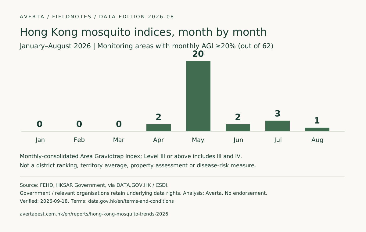
How many monitoring areas reached Level III or above each month?
Monthly-consolidated Area Gravidtrap Index ≥20%; denominator: 62 areas each month.
Source: FEHD 2026 monthly-consolidated AGI; area counts calculated by Averta. Not a territory-wide average index.
FEHD monitoring areas are not whole administrative districts and do not describe mosquitoes at a particular home, shop or other property. The index does not measure disease risk. A missing published value remains missing and is never converted to zero. For the latest monthly series, use the live index tracker.
01 / REPEATED HIGH READINGS
Monitoring areas with repeated Level III-or-above months
Here, “repeated” means at least two months at ≥20% from January to August, not necessarily consecutive. All qualifying areas are shown below.
| Monitoring area | Jan | Feb | Mar | Apr | May | Jun | Jul | Aug | Months ≥20% | Longest run |
|---|---|---|---|---|---|---|---|---|---|---|
| Cheung Sha Wan | 0.0 | 0.0 | 0.9 | 8.5 | 25.7 | 29.2 | 32.1 | 9.3 | 3 | 3 |
| Lam Tin and Sau Mau Ping | 0.0 | 0.0 | 0.8 | 9.4 | 27.7 | 40.2 | 18.4 | 26.4 | 3 | 2 |
| Sheung Shui | 0.8 | 0.0 | 0.0 | 20.3 | 29.3 | 10.0 | 8.9 | 4.9 | 2 | 2 |
| Ma On Shan | 0.0 | 0.0 | 1.6 | 16.4 | 31.0 | 18.5 | 22.7 | 8.1 | 2 | 1 |
02 / MONTH-TO-MONTH CHANGE
July-to-August changes (percentage points)
Subtracting index percentages gives percentage points, not percentage growth. The changes do not explain their causes. The five largest increases and decreases are shown.
Largest increases
| Monitoring area | Jul → Aug | pp |
|---|---|---|
| Lam Tin and Sau Mau Ping | 18.4 → 26.4% | +8.0 |
| Tung Chung | 1.0 → 5.2% | +4.2 |
| Sheung Wan and Sai Ying Pun | 16.1 → 19.5% | +3.4 |
| Sha Tin East | 5.0 → 8.1% | +3.1 |
| Yau Tong and Cha Kwo Ling | 2.7 → 5.4% | +2.7 |
Largest decreases
| Monitoring area | Jul → Aug | pp |
|---|---|---|
| Cheung Sha Wan | 32.1 → 9.3% | -22.8 |
| Tai Po East | 19.6 → 3.9% | -15.7 |
| Ma On Shan | 22.7 → 8.1% | -14.6 |
| Tai Po West | 15.5 → 2.7% | -12.8 |
| Tin Shui Wai | 16.2 → 6.0% | -10.2 |
Check all 62 areas
Open the complete January–August table
| District label | Monitoring area | Jan | Feb | Mar | Apr | May | Jun | Jul | Aug |
|---|---|---|---|---|---|---|---|---|---|
| Central and Western | Central and Admiralty | 0.0 | 0.0 | 1.0 | 0.0 | 14.2 | 3.8 | 6.7 | 6.7 |
| Central and Western | Kennedy Town and Shek Tong Tsui | 0.0 | 0.0 | 0.0 | 6.7 | 16.8 | 7.4 | 7.6 | 4.6 |
| Central and Western | Sheung Wan and Sai Ying Pun | 0.0 | 0.0 | 1.8 | 3.5 | 20.5 | 8.8 | 16.1 | 19.5 |
| Eastern | Chai Wan | 0.0 | 0.0 | 0.8 | 7.3 | 15.4 | 16.9 | 16.3 | 12.2 |
| Eastern | North Point and Quarry Bay | 0.0 | 0.0 | 0.0 | 6.8 | 18.9 | 9.9 | 13.8 | 4.1 |
| Eastern | Shau Kei Wan and Sai Wan Ho | 0.9 | 0.0 | 0.0 | 12.6 | 17.0 | 14.3 | 19.6 | 10.7 |
| Southern | Aberdeen and Ap Lei Chau | 0.0 | 0.0 | 0.9 | 6.5 | 20.8 | 9.2 | 14.7 | 9.1 |
| Southern | Deep Water Bay and Repulse Bay | 0.0 | 0.0 | 0.0 | 5.9 | 12.5 | 7.5 | 3.4 | 3.3 |
| Southern | Pok Fu Lam | 0.0 | 0.0 | 0.0 | 4.3 | 15.2 | 13.3 | 6.8 | 7.0 |
| Wan Chai | Happy Valley and Tai Hang | 0.0 | 0.0 | 1.8 | 3.5 | 16.7 | 4.3 | 5.1 | 2.6 |
| Wan Chai | Tin Hau and Causeway Bay | 0.0 | 0.0 | 0.0 | 7.6 | 8.8 | 8.3 | 5.8 | 3.8 |
| Wan Chai | Wan Chai | 0.0 | 0.0 | 0.0 | 4.5 | 5.5 | 4.5 | 3.7 | 0.9 |
| Islands | Cheung Chau | 0.0 | 0.0 | 0.9 | 7.3 | 12.0 | 9.3 | 4.7 | 1.8 |
| Islands | Tung Chung | 0.0 | 0.0 | 0.0 | 1.0 | 4.0 | 4.9 | 1.0 | 5.2 |
| Kowloon City | Ho Man Tin | 0.0 | 0.0 | 0.9 | 5.3 | 23.6 | 14.0 | 8.9 | 6.5 |
| Kowloon City | Hung Hom and To Kwa Wan | 1.8 | 0.0 | 1.8 | 6.1 | 17.2 | 7.9 | 18.1 | 15.0 |
| Kowloon City | Kai Tak | 0.0 | 0.0 | 1.0 | 10.6 | 12.8 | 9.4 | 24.2 | 14.6 |
| Kowloon City | Kowloon City | 0.0 | 0.0 | 0.0 | 7.4 | 10.3 | 5.6 | 4.7 | 2.8 |
| Kowloon City | Kowloon Tong | 0.0 | 1.7 | 2.5 | 8.5 | 23.4 | 10.8 | 9.1 | 9.0 |
| Kwun Tong | Kowloon Bay | 0.0 | 0.0 | 0.0 | 9.8 | 28.9 | 8.8 | 7.1 | 9.3 |
| Kwun Tong | Kwun Tong Central | 0.0 | 0.0 | 0.0 | 2.4 | 37.3 | 14.1 | 4.8 | 4.8 |
| Kwun Tong | Lam Tin and Sau Mau Ping | 0.0 | 0.0 | 0.8 | 9.4 | 27.7 | 40.2 | 18.4 | 26.4 |
| Kwun Tong | Yau Tong and Cha Kwo Ling | 0.0 | 0.0 | 0.0 | 0.9 | 16.2 | 10.3 | 2.7 | 5.4 |
| Mong Kok | Mong Kok and Tai Kok Tsui | 0.0 | 0.0 | 0.0 | 1.7 | 0.9 | 3.4 | 0.8 | 1.7 |
| Sham Shui Po | Cheung Sha Wan | 0.0 | 0.0 | 0.9 | 8.5 | 25.7 | 29.2 | 32.1 | 9.3 |
| Sham Shui Po | Lai Chi Kok | 0.0 | 0.0 | 0.0 | 4.4 | 9.0 | 8.3 | 9.2 | 7.1 |
| Sham Shui Po | Sham Shui Po and Shek Kip Mei | 0.0 | 0.0 | 0.0 | 5.7 | 26.2 | 3.3 | 4.9 | 4.2 |
| Wong Tai Sin | Diamond Hill and Tsz Wan Shan | 0.0 | 0.0 | 0.8 | 8.4 | 16.7 | 15.8 | 15.0 | 13.4 |
| Wong Tai Sin | Ngau Chi Wan and San Po Kong | 0.0 | 0.0 | 0.0 | 17.8 | 14.7 | 11.1 | 9.2 | 6.4 |
| Wong Tai Sin | Wong Tai Sin East | 0.0 | 0.0 | 0.0 | 9.8 | 16.7 | 15.8 | 8.6 | 5.4 |
| Wong Tai Sin | Wong Tai Sin West | 0.0 | 0.0 | 1.0 | 2.8 | 18.1 | 6.5 | 3.8 | 2.0 |
| Yau Tsim | Tsim Sha Tsui and Yau Ma Tei | 0.0 | 0.0 | 0.0 | 7.1 | 4.8 | 0.0 | 6.3 | 2.4 |
| Yau Tsim | Tsim Sha Tsui East and King's Park | 0.0 | 0.0 | 0.0 | 2.8 | 9.1 | 6.5 | 6.5 | 0.0 |
| North | Fanling North | 0.0 | 0.0 | 0.0 | 2.4 | 13.1 | 2.4 | 0.0 | 0.0 |
| North | Fanling South | 0.0 | 0.0 | 0.0 | 8.4 | 14.9 | 18.2 | 14.4 | 5.8 |
| North | Sheung Shui | 0.8 | 0.0 | 0.0 | 20.3 | 29.3 | 10.0 | 8.9 | 4.9 |
| Sai Kung | Sai Kung Town | 0.0 | 0.0 | 5.7 | 16.8 | 22.1 | 11.3 | 2.9 | 3.9 |
| Sai Kung | Tseung Kwan O East | 0.0 | 0.0 | 0.0 | 8.9 | 27.0 | 3.4 | 7.5 | 2.8 |
| Sai Kung | Tseung Kwan O North | 0.0 | 0.0 | 1.1 | 13.6 | 35.3 | 12.9 | 8.0 | 6.8 |
| Sai Kung | Tseung Kwan O West | 0.0 | 0.0 | 0.0 | 6.4 | 8.4 | 8.2 | 8.2 | 7.3 |
| Sha Tin | Ma On Shan | 0.0 | 0.0 | 1.6 | 16.4 | 31.0 | 18.5 | 22.7 | 8.1 |
| Sha Tin | Sha Tin East | 0.0 | 0.0 | 0.8 | 4.1 | 19.0 | 8.9 | 5.0 | 8.1 |
| Sha Tin | Sha Tin Town Centre and Fo Tan | 0.0 | 0.0 | 0.0 | 9.3 | 18.3 | 11.0 | 7.5 | 8.6 |
| Sha Tin | Tai Wai | 0.0 | 0.0 | 0.0 | 5.0 | 24.2 | 4.8 | 0.0 | 2.5 |
| Tai Po | Tai Po East | 1.1 | 0.0 | 0.0 | 34.7 | 10.2 | 6.7 | 19.6 | 3.9 |
| Tai Po | Tai Po West | 0.0 | 0.0 | 0.0 | 7.0 | 16.4 | 16.8 | 15.5 | 2.7 |
| Kwai Tsing | Kwai Chung East | 0.0 | 0.0 | 0.0 | 15.2 | 7.2 | 7.0 | 7.2 | 3.5 |
| Kwai Tsing | Kwai Chung West | 0.0 | 0.0 | 0.0 | 4.5 | 17.8 | 16.7 | 15.6 | 7.8 |
| Kwai Tsing | Lai King | 0.0 | 0.0 | 1.0 | 6.6 | 26.9 | 8.7 | 16.3 | 9.6 |
| Kwai Tsing | Tsing Yi North | 0.0 | 0.0 | 0.8 | 8.4 | 30.0 | 6.8 | 10.2 | 11.7 |
| Kwai Tsing | Tsing Yi South | 0.0 | 0.0 | 0.0 | 8.8 | 15.0 | 7.9 | 7.1 | 5.2 |
| Tsuen Wan | Ma Wan and Sham Tseng | 0.9 | 0.0 | 0.9 | 4.6 | 26.2 | 9.5 | 9.1 | 7.3 |
| Tsuen Wan | Sheung Kwai Chung | 0.0 | 0.0 | 1.0 | 4.7 | 10.3 | 7.3 | 4.5 | 5.5 |
| Tsuen Wan | Tsuen Wan Town | 0.0 | 0.0 | 0.0 | 5.2 | 6.9 | 8.5 | 6.9 | 5.1 |
| Tsuen Wan | Tsuen Wan West | 0.0 | 0.0 | 0.0 | 4.0 | 28.6 | 6.5 | 8.5 | 2.8 |
| Tuen Mun | So Kwun Wat | 1.8 | 0.0 | 1.8 | 19.3 | 20.5 | 6.1 | 11.7 | 3.6 |
| Tuen Mun | Tuen Mun North | 0.0 | 0.0 | 0.0 | 7.3 | 9.4 | 6.3 | 5.5 | 3.1 |
| Tuen Mun | Tuen Mun South | 0.0 | 0.0 | 0.9 | 11.8 | 15.5 | 7.3 | 9.2 | 7.3 |
| Tuen Mun | Tuen Mun West | 0.0 | 0.0 | 0.0 | 17.3 | 12.4 | 3.0 | 9.1 | 3.0 |
| Yuen Long | Hung Shui Kiu and Ping Shan | 0.0 | 0.0 | 0.0 | 3.2 | 14.3 | 5.3 | 3.2 | 1.2 |
| Yuen Long | Tin Shui Wai | 0.0 | 0.0 | 1.0 | 6.1 | 13.0 | 17.2 | 16.2 | 6.0 |
| Yuen Long | Yuen Long Town | 0.0 | 0.0 | 0.0 | 5.2 | 18.1 | 6.9 | 13.2 | 13.6 |
Method and scope
Each value is FEHD's published monthly-consolidated Area Gravidtrap Index. Repeated high months count the months at Level III or above for the same monitoring area; consecutive run is the longest uninterrupted run at that level. Latest changes are percentage-point changes. Repeated readings are ordered by number of qualifying months, longest run, then latest value; remaining ties retain source order. Monthly changes are ordered by percentage-point change, with source order breaking ties.
CSDI numeric values are rounded to FEHD’s published one-decimal precision. All 496 observations match the monthly-consolidated table. Reproduce the API query · Open-data terms
- Only January–August 2026 monthly-consolidated AGI is used. First-phase indices and Area Density Index (ADI) are excluded.
- FEHD bands: I <5%; II 5–<20%; III 20–<40%; IV ≥40%. “Level III or above” includes Levels III and IV.
- The August snapshot is retained. Future observations will not overwrite it; any source correction requires a separately labelled edition and explanation.
Download the fixed snapshot
The UTF-8 CSV includes bilingual names for all 62 monitoring areas, monthly values, snapshot version, source URL and verification date. It is immutable and will not be overwritten when the live tracker refreshes.
A chart for your article or presentation
Date, denominator and source stay with the chart. Use SVG for scaling or PNG for a document.
Suggested citation
Averta Pest Control, Hong Kong Mosquito Trends 2026: a 62-area January–August snapshot, edition 2026-08. Data: FEHD, HKSAR Government, via DATA.GOV.HK / CSDI; Government and relevant organisations retain underlying data rights. Retain observation dates and method limitations. https://avertapest.com.hk/en/reports/hong-kong-mosquito-trends-2026
You are welcome to cite our original analysis and chart. Keep FEHD attribution, observation dates and limitations; Averta does not own the underlying government data. Linking here helps readers check the method, but a backlink is not a condition of using our original materials.
Before you use this resource
Is this a Hong Kong mosquito-risk ranking?
No. It orders published Area Gravidtrap Index values for FEHD's 62 monitoring areas only; it does not average them into Hong Kong, district or property rankings.
Does Level III mean disease risk?
Disease risk cannot be inferred from the index alone. Level III is an FEHD surveillance band; this resource does not estimate disease risk or conditions at an individual property.
Why is this fixed at August 2026?
This is a citable historical snapshot. Use the live mosquito index tracker for the current monthly series; the two should not be treated as the same edition.